In a first-of-its-kind move for Uttar Pradesh, Noida has officially rolled out Google’s real-time Speed Limit integration on Maps, giving commuters instant access to accurate speed limits right on their navigation screens. The initiative, led by IPS Dr. Rajeev Narain Mishra, Additional Commissioner of Police, Noida, is being hailed as a breakthrough in digital traffic management and public safety.
A Simple Fix to a Complicated Problem
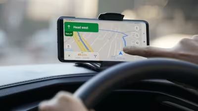
For years, drivers across India have relied on guesswork due to missing or outdated speed limit boards. Google Maps could show vehicle speed — but not the actual legal limit. Noida’s new integration fixes this gap with a simple, intuitive solution:
Two circles on the screen — one showing the permitted speed and the other showing the driver’s current speed.
The moment a driver sees both values side by side, behavioural correction happens almost instantly.
Dr. Mishra explains it best:
“When allowed speed sits next to your own speed, the mind automatically adjusts. It becomes guidance, not enforcement.”
How Noida Pushed This Project Into Reality
The project was born from a realisation: most traffic violations were happening not because of recklessness, but because of inconsistent information. During his earlier posting as SP Traffic, Dr. Mishra had overseen large-scale camera installations — an experience that helped him visualise how tech could be integrated directly into public mobility.
He coordinated with:
■Google’s strategic partnership team
■Lepton Software for technical mapping
■Local authorities for validating speed limits
The biggest challenge?
Different agencies had set limits at different times. Compiling, verifying, and aligning them into a single, accurate database required deep patience and precision.
Where limits clashed, the team chose the safer, more conservative value.
Not Enforcement — A Cultural Shift
The Noida Police is now running city-wide awareness drives targeting:
■Two-wheeler riders
■School van operators
■Delivery riders
■Public transport drivers
The goal is simple:
Replace fear-driven enforcement with informed, self-regulated behaviour.
Dr. Mishra emphasises,
“A small alert on the screen can save a life. If we give people clarity, the responsibility naturally follows.”
What Comes Next: Accident Hotspots on Maps
The next phase aims to map verified accident-prone zones across Noida and make them visible on Google Maps.
Drivers will receive alerts before entering high-risk stretches — a move expected to drastically enhance situational awareness.
Each hotspot undergoes a multi-layer verification:
1. Identified by Noida Police
2. Validated internally
3. Independently checked by Google
4. Only then updated to Maps
A Model for Smart, Humane Traffic Management
With this rollout, Noida has positioned itself as a national model for tech-enabled road safety.
Instead of relying solely on penalties, the city is focusing on real-time information, transparency, and behavioural nudges.
Under the leadership of IPS Dr. Rajeev Narain Mishra, Noida has bridged a long-standing information gap, proving how thoughtful digital interventions can guide drivers more effectively — and more gently — than traditional enforcement.
This is not just a feature upgrade.
It’s the beginning of a new era where smart cities use smart tools to make everyday commuting safer for everyone.